
This map charts out the number of people in every square kilometer of the United States.
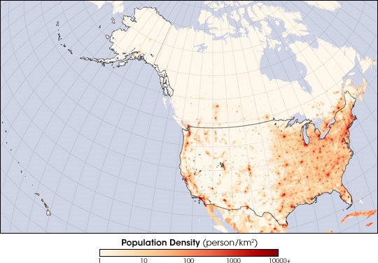
As has been the case historically, the most densely populated parts of the United States are east of the Mississippi River. Rings of decreasing population density radiate out from the major urban centers of New York, Philadelphia, and Washington along the East Coast. Other cities—Atlanta, Chicago, Houston, and Dallas—punctuate the map in the country’s interior. The west remains lightly populated except for clearly defined urban regions. Like their counterparts in the east, the largest cities in the west (San Diego and Los Angeles; San Fransisco, Oakland and San Jose) hug the coast, with the densest populations in Southern California. Other large western cities readily visible here include Portland, Seattle, Phoenix, and Denver.
2 comments:
Well, I guess I am glad I am awake at this crazy hour in another large western city readily visible here. And you are awake too!
Thanks for the geography leason.
Post a Comment