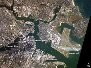
 r trying to observe Boston’s “Big Dig”, the local transportation project that is now the largest civil engineering project in U.S. history? Regardless of the reason, this image provides a good bird’s-eye view of the center of the city, including famous colonial and independence locations extending from Boston Common to the North End.
Wispy clouds hover over the south end of Logan Airport. Ship traffic in the Charles and Mystic Rivers is marked by the wakes of the ships. And highly reflective construction locations, including the new I-93 and bridge over the Charles River, and highway exchanges at Logan Airport mark new elements of Boston’s Big Dig.
This photograph was taken October 20 , 2003 with a Kodak DCS760 digital camera equipped with an 800 mm lens and provided by Cynthia A. Evans (Lockheed Martin / Earth Observations Laboratory, Johnson Space Center).
Visit NASA's EARTH OBSERVATORY online.
The photos are out of this world.

4 comments:
Queen Noor is left quite breathless!
Awesome! I've driven the "Big Dig" often - twice yesterday. Fenway Park - one of my favorite places on earth. Logan Airport - take me away please! Come visit.
Peace,
JJ
That Earth Observatory site is awesome! Thanks for the link!
I liked visiting Boston, but their streets signs are so tiny and almost invisible, it made for difficult driving. On the other hand, I miss the other Boston.
Post a Comment